Welcome to The Next Trail. We hope the App lets you enjoy your trail riding even more!
Here is a short video describing the very first steps to use The Next Trail App.
First, download The Next Trail app from the Apple App Store or the Google Play Store.
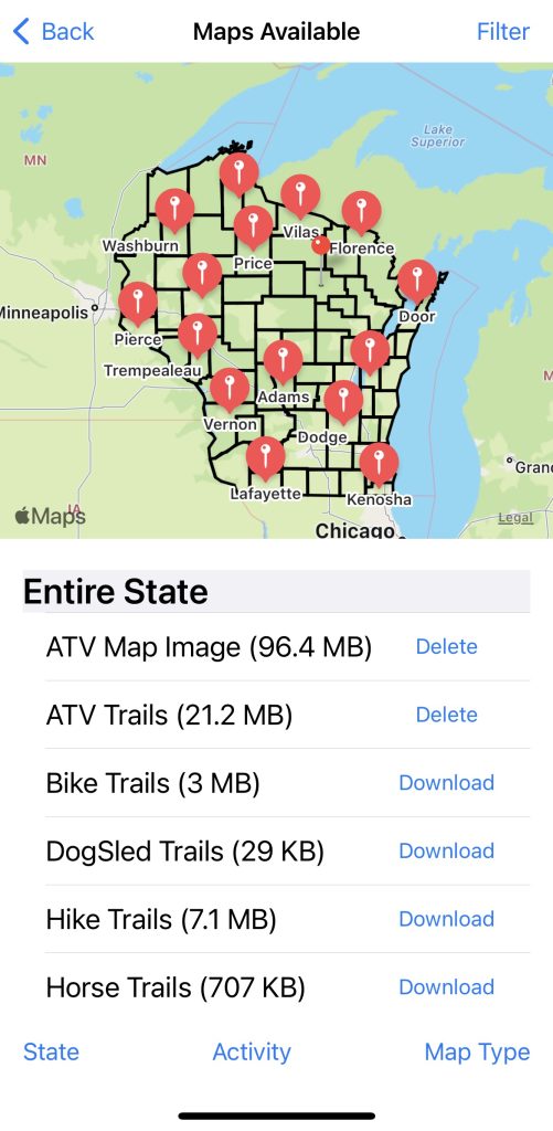
To get detailed map/trail information you must download the trails or map images when you have good internet service. We do not download all maps automatically as they take up space on your phone/device. Instead you can choose maps for individual counties or areas or optionally you can download data for an entire state(s). Once downloaded, internet service is not needed when trail riding.
The app has two types of data. A “Trail” which is GPS data (GIS Data) provided by a club/county/state so it is very precise. A “Map Image” a digital copy of the paper maps from clubs, counties or states. Note for each county/area, there may be Snowmobile, ATV, Hiking, etc. data available. Press “Download” next to as many Trails/Map Images as you’d like – all data is included with your subscription.
In the lower right corner, select the folded map button ![]() . This will display a list of all trails and map images for the state you are currently located in. To view maps for a different state, simply press the “States” button in the lower left and choose a state. Note: we only list the states where data is available.
. This will display a list of all trails and map images for the state you are currently located in. To view maps for a different state, simply press the “States” button in the lower left and choose a state. Note: we only list the states where data is available.

Not all counties have map images or trails. We will add them as they become available. You can scroll through the list to Download the data you might use. You can also use the map on the top of the screen to select one of the red tear drops to select a county where data is available and the list will move to that counties data. Once you have downloaded data to your device, you no longer need internet service for the map/trail to appear on your device.
Important: When you go back to the main page, in the upper right you can select what type of data you want (Snowmobile, ATV, Winter ATV, etc.).
Remember not all counties have all the different types of data. On the main page, you can also select the layers button ![]() to choose if you’d like to see the Map Image data or the Trails data.
to choose if you’d like to see the Map Image data or the Trails data.
As you move from county to county, the data that you have downloaded, for the county/area you are currently in, is displayed. You can also move the cursor to other counties/areas to see map/trail information you have downloaded.
Here is a quick tutorial on downloading trails and map images…
